WISE-UP links ecosystem services more directly into water infrastructure development in the Tana (Kenya) and Volta (Ghana-Burkina Faso) river basins

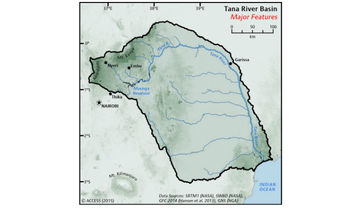
The Tana River Basin, Kenya
The Tana River, Kenya’s longest river, flows for approximately 1000km draining a catchment of 126,026km². Growing competition amongst water users is projected to intensify with the development of new hydropower plants, climate variability, as well as increasing urban, agricultural, and ecosystem demands. The Tana river is also the only river providing water to the lower delta inhabited by a poor and vulnerable population. River sediments and nutrients support the health of beaches and marine parks, critical contributors to Kenya’s national economy.
A critical challenge was identified as adapting water management to climate change impacts, while finding ways of equitably and efficiently balancing competing water demands. In the Tana river basin, long-term climate resilient and sustainable solutions satisfying all water users and water developed will need to be implemented in order to avert conflict, livelihood losses, ecosystem degradation and economic hardship. Results from WISE-UP provide policymakers, water users and scientists with evidence and solutions to integrate built infrastructure into the basin's natural ecosystem, that is critical for national development.
Key issues in the Basin
The Tana River Basin has a unique set of conditions within which WISE-UP operates, and this has highlighted a number of considerations. Below are the key points that we need to understand in order to address cross-cutting issues such as poverty reduction and climate change adaptation.
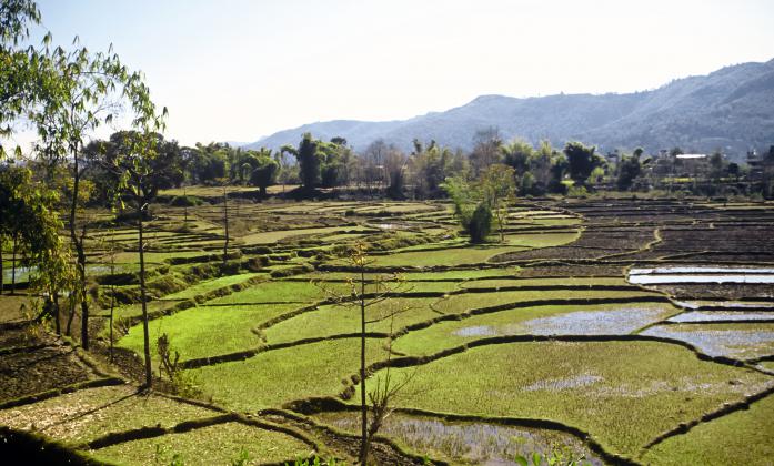
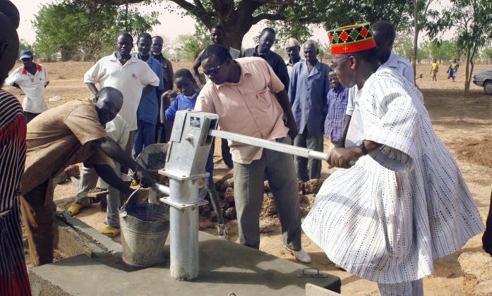
- Competing Water Demands - there is strong competition for water resources among many different actors: irrigation, fishing, horticulture, rice production, hydropower, domestic water use, drinking water supply for major towns.
-
Extreme Weather Fluctuations - climate change is expected in the long-term to increase rainfall in the basin, but with increased extremes including drought. Floods and droughts have displaced populations within the basin; the East African region is likely to have an increase in mean annual precipitation during the rainy season alongside frequent and extreme droughts during the dry season (IPCC, 2007).
-
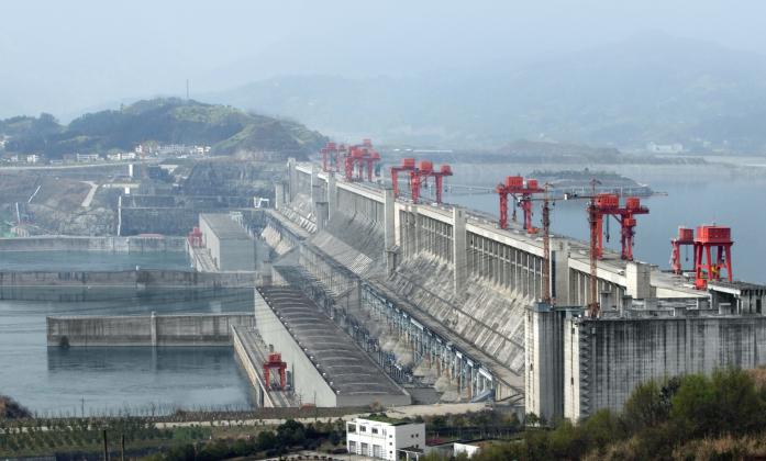
Downstream Impact - impacts of dam construction upstream (providing 60% of Kenya’s electricity) on the downstream ecosystem and populations. There is an urgent need to maintain instream flows and the natural flooding regime of the Tana to support dry season grazing, fisheries, floodplain agriculture and the various water-dependent natural ecosystems (such as forests, wetlands and mangroves) vital to local livelihoods.
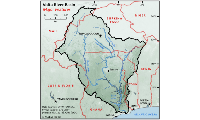
The Volta River Basin, Ghana - Burkina Faso
The Volta River Basin in West Africa covers 417,000 km2 and is shared by six countries: Ghana, Burkina Faso, Mali, Côte d’Ivoire, Togo and Benin. The WISE-UP project focuses on the part of the Volta River running through Ghana and Burkina Faso. Water resources in the basin are under stress, as a result of increasing demand due to high population growth, variability of rainfall and runoff, and uncoordinated water resources development. Flooding, water shortages and pollution, loss of biodiversity, waterborne diseases, and proliferation of aquatic weeds affect the region’s poor disproportionately.
The critical water resource challenges in the basin can be addressed through better mechanisms for coordination amongst riparian States, through increased water storage for subsistence farmers, by reducing waterborne disease, and supporting biodiversity, and deriving maximum benefits from hydropower through existing and planned hydropower plants. WISE-UP in the Volta Basin provides analysis, information and tools to help governments, basin agencies, and stakeholders assess options for climate-resilient water infrastructure development and the associated trade-offs.
Key issues in the Basin
The Volta River Basin presents a complex matrix of environmental and population concerns which need to be addressed by WISE-UP while we work towards larger-scale issues, like poverty reduction and climate change adaptation. Below are a few of the key points of consideration, especially concerning the regions of the basin which lie in Ghana and Burkina Faso.
-
Climatic Changes - low and erratic rainfall with a prolonged dry season and floods and droughts, high temperatures & evapotranspiration rate, changes in water quantity and seasonal flows have resulted in low seasonal runoff.
-
Rising Demand - high population growth rates can put a great deal of stress on water resources (growth rate: 2.54%).
-
Landscape Degradation - in rural areas where people rely most directly on ecosystem services, vulnerabilities to climate change, as well as water and food insecurity, are exacerbated by watershed degradation and biodiversity loss.
-
Water Quality - issues with irrigation in rural areas can cause concerns over water quality, and the resulting effect it will have on the local population and food supply.
-
Transboundary Governance Challenges - Ghana and Burkina Faso have contrasting needs from the river and potentially conflicting strategies for water resources management. Burkina Faso focuses on water storage to meet dry-season needs for households and livestock watering. Downstream, Ghana attaches great importance to hydropower development to meet energy needs for industrialisation.
New policy in the Tana and Volta river basins will need to better address the interdependencies of growth, poverty and climate change adaptation in order to respond to the above mentioned challenges for each basin. Growth, poverty reduction and climate change adaptation are issues with the highest priority on the policy agenda for developing countries and in multilateral mechanisms at the global level. Relevant policies are evolving rapidly. The 2008 global food crisis and the urgent need for improved global food security, the agreement in 2010 of the Cancun Adaptation Framework and formation of the Green Climate Fund under the UNFCCC, the agreement at Rio+20 to formulate a set of global Sustainable Development Goals and the post-2015 review of the Millennium Development Goals are responses to social, environmental and economic stresses. Water infrastructure is given high priority as an asset for growth and poverty reduction and in strategies for climate change adaptation and major new climate financing. This shifting policy landscape provides critical opportunities for re-framing of policy approaches.